Tuesday, June 30, 2015

More fossils and birds

Our next to last day in El Califate, we took another day trip to look at fossils.  This was another package tour, catchily named the Bosque Petrificado (Petrified forest), which picked us up at our hotel and took us to an estancia where we were going to do a guided walk and look at petrified wood.  The estancia, near the river Leona, was on Lago Viedma between El Califate and El Chalten, so we went north on highway 40 this time.

Our guide was super-knowledgeable so we learned a ton about geology. We first stopped in a road-side cafe to pick up some folks from El Chalten that were part of the guided tour.  Then we went off road, past cattle gates, and onto bumpy estancia roads.  Through lots of scrub to get to a lime-stone moonscape:

This land had been part of a pre-historic river delta in the times before the continents all split apart, and over time the sandstone was uncovered and eroded.  In places, there were more durable layers that protected under-layers from erosion.  Today, most of the movement of this land occurs over a week or so of the spring melt.  There is very little precipitation here, and almost all of it is snow.  In the first spring melt, it turns into running water and forms the washed-looking eroded cap for the year. 

While we walked around the circuit with the guide, listening to explanations, the kids explored the hills and listened a little.


There were several examples of dinosaur bones, but the coolest fossils were trees.  There were lots of parts of petrified trunks.

We ate lunch out of the sun in some sandstone eroded caves, walked out of the valley and up to the van for the ride home.

Our last day in El Califate was a half-day, as we flew out in the afternoon to Bariloche, so we went for a walk in a bird preserve outside downtown on the shores of Lago Argentina.  It's a couple of a kilometer circuit, and it's incredibly different from the desert-moon-like landscape we'd seen on the steppe the day before on the fossil walk.

This is shows a colony of flamencos.  We stayed on boardwalks and clearly-signed paths, which didn't get very close to where the flamencos were in the lake.  But we did see a ton of birds.  All of this at the outlet of a creek into the lake, a fragile lake-side marshy ecosystem that supports tons of bird life.


Wednesday, June 24, 2015

Uppsala Glacier and Estancia Cristina

One very long day in January 2015, we did a day trip from El Califate to Estancia Cristina. We took a  fast catamaran from the port outside El Califate to down the lake to Estancia Cristina, a tourist estancia on National Park land that is close to Glaciar Uppsala, another huge glacier that feeds into Lago Argentina and that is retreating.  This is a standard day-trip from El Califate, and we'd chosen the trip option that included a 4x4 ride up to a short hike to a viewpoint of the glacier. 
The hike up to the glacier included a pass by marine fossils in rocks.  It was my first time just seeing fossilized remains hanging around.   This was pretty near the lookout where we saw one arm of Uppsula Glacier.  There was tons of barren rock, like a moonscape, without even the expected scrubby growth we'd passed by in the 4 x 4.    This is because all of this land, fossils and all, had been under the glacier for thousands of years.  In the last few decades, the glacier has retreated several kilometers.  There is a new glacial lake, which you can see behind Mike and Silas in the photo below, and there has been no time for erosion to create enough topsoil on the glacially scraped rock for anything to start growing.

The arm of Uppsula Glacier that is behind Mike and Silas is the side, not the main face of the glacier.  The main arm is on the other side of an island.   This Glacier comes at an angle off the icesheet, which is one of the reasons it is retreating so quickly.   On the hills on the side of the glacier, you can see bare rock, and then above that, trees, marking most recent line of the maximum height of the glacier.  We're talking a lot of melting ice.

The walk up to the viewpoint, taken from the viewpoint ridge looking back towards the estancia grounds.  This lake was not glacially fed, but was filled with snowmelt.  It is completely different in color from the glacially-fed lakes.  In the background, you can see that one row of hills over was not recently covered by glaciers and had vegetation.

On the way back to El Califate, we went up another arm of Lago Argentina to see the main face of Uppsula Glacier.  You can't actually get close enough to see much of the glacier because there is an ice wall, meaning that there are so many icebergs in the lake that it's dangerous to go closer to the glacier.  Many were blue ice, and in fantasitcal shapes.


Monday, June 22, 2015

Family Ziplining

There are lots of opportunities to go ziplining in Patagonia, one in every town. Pagatonia is into outdoor adventure tourism, with touts for ziplines (tirolesa), horsebackriding, rockclimbing, 4x4 rides, and trekking.  The kids had been talking about going on a zipline since Ushuaia, where there is a course through the trees at the bottom of the ski slope leading up to Glaciar Martial.  So in El Califate, we found a zip line course that would allow adventurous 5-year-olds and decided to go for a ride.  We found this one by walking down the main drag in El Califate and stopping in at their storefront booking office.  For some reason, both this activity and the fossil walk we did later in the week were not in the guidebooks, and both were great.

The course was on an estancia, of course.  Every estancia tries to make the biggest possible tourist buck out of their resources.  This estancia, Cerro Frias, had a fancy hotel, ziplining, 4x4 riding and other activities, as well as a restaurant/outfitting area.   Like with many day activities, the estancia van picked us up in our hotel and took us to the estancia, about 20 K outside El Califate towards the mountains.  Those 20 K made a big difference in the vegetation, as the closer you are to the mountains, the more precipitation.  And since the estancia is close to Lago Argentina, which was formed as glaciers retreated, it's lucky enough to have a big hill with a nice valley and 2 parallel ridge lines.   I'm unclear if this is a foothill or a glacial moraine. They use the ridge lines to run the zipline across the gorge.  So we weren't in trees in the woods, but rather zipped from one ridge line to another over the 500 M wide gorge.  It was awesome. 

First, we got fitted up there in helmets and harnesses.   From there, we went uphill on a 4x4 track to the first platform.
From the parilla/gear shop, there was  a great view back of over the estancia's piece of Patagonian prairie, with a view of Torres del Paine, Chile, in the distance.  That part of the estancia was good for grazing, and the few patches of green are fields of alfalfa that they grow with irrigation to supplement the livestock's diet.  There are also some free-range guanaco under the trees.

The part we were on for the zipline was also used for cattle, and we passed a few overhead. 


Our zip lining guides were great.  They called Silas "Puma" as he was into pumas, the apex Patagonian predator,  and Maeve "Pluma," or feather.  Mike and I were Mama and Papa.  There were several other folks in our group, including a couple of rotund gentlemen, and they were called "musculoso."  The kids thought this nicknaming was great, as the guides talked back and forth on their radios, letting the other side know who was coming so they'd be ready for the landing and getting the OK.  Silas wanted very badly to go on his own, but he was generally too light and went hitched onto Mike.

Maeve had a great time.  Except for one time when she rode tandem with me, giving us enough mass to go a bit faster, she went on her own.  You can see the take off pad on the other side of the canyon.

On the last run, they let Silas go on his own because there was enough downward pitch that he could make it to the end.  He was screaming and doing acrobatics the whole 500 M.  An awesome day.

Friday, June 19, 2015

Perrito Moreno Glaciar

We spent about a week in El Califate in late January.   Every day was a new adventure, but the main reason we'd come was to see the Perito Moreno Glacier.  This is one of the few glaciers that is stable, as it comes directly off the ice sheet.  Over the past 100 years it has kept to a constant cycle of growing and retreating into Lago Argentina, where it periodically comes to rest on a peninsula and then breaks off massively.  But there are regular glacial calvings, small and big, as part of the glacier falls into the lake.  Right now, it's several hundred meters from the peninsula, and there are great views of the leading edges of the glacier from a couple kilometers of boardwalks.
This is a view of the mountains, Lago Argentina, and the valley Perrito Moreno slides out of from the Glaciarium, a museum about glaciers 10 K outside El Calefate.   We spent a morning here, learning about ice compaction, global warming, and the southern Patagonian icesheet.

We did a day trip to Perito Moreno which included a short hike in the park.  This was one of our first views of the SW edge of the glacier.  A little closer, you can see icebergs floating in the lake and the milky color of the glacial silt in the water. 

It's hard to explain how impressive the massive wall of ice was.  Each face was about a kilometer long, in this photo you can see the leading edge that's not far from the peninsula with the boardwalks as well as one of the sides.

On the boardwalks, we saw numerous small calvings.  You can see where ice has fallen and it spreading out in concentric half-circle from the wall of the glacier.  We were on a boat in the morning looking at one face, and spent the afternoon on the boardwalks, when the sun was off and on on the glacier.  We saw a lot more calvings in the afternoon.


This photos is actually from a bathroom break on the way to the glacier.  We got off at a small estancia that had a cafe with bathrooms and resident sheep and guanaco babies. Maeve and Silas both got to give them a bit of milk.  The sheep was particularly aggressive to get to the bottle, and its fur was filled with burrs.


Thursday, June 18, 2015

Nibepo Aike

Nibepo Aike is an Estancia about 60 KM outside of El Califate, Argentina.  Dude ranches are a big thing in Patagonia.  It turned out to also be a great place for walking.  We stayed some time in the Califate area, in order to see the glaciers, and chose not to spend time in El Chalten, on the northern end of the park, where there is more trekking.  So we had to look around a bit for places to walk.  Nibepo Aike is on land right next to the the Glacier National Park and it considered a park concession, so it has to follow by all the national park rules.  It was a privately owned estancia that had sheep and cows, but is now based on tourism, as it is limited in the number of sheep it can have by national park rules so it has only a demonstration herd.  It's snuggled right next to the southern arm of Lake Argentina (the largest lake in Argentina), which is fed by rain water/snow and Perito Moreno Glacier.  Since it's pretty close to the mountains, it gets some rain fall and can support scrubby bush, particularly califate bushes and some mixed Nothofagus woods.  Even 20 K further from the mountains, the rainfall (snowfall) decreases precipitously and there is only scrubby arid steppe.  It was a great, if expensive, stay, complete with great food including fresh milk from their Jersey cows with blobs of fat floating on it.

The first day, we got a tour of the working farm, including a sheep-shearing demonstration using old-timey scissors.   We went for a walk down farm roads, along the lake and through some paths (somewhat hard to find, as usual for us).  We walked towards the mountains.    We threw lots of rocks in the river and build small rock docks for walking out on to throw in more rocks and sticks. The scenery was amazing. 

On the way back to the ranch house, we found a lot of califate bushes. We love to eat wild berries on our hikes in the Pacific Northwest, and Mike and I had tried the Pan de Indio (and edible tree-growing fungus), once we knew what it was, in Tierra del Fuego, but that wasn't such a tasty treat.  El Califate is named for the califate bush, a scrubby, thorny, hardy thing that grows all over the arid Patagonian steppe that produces tasty small purple berries with lots of seeds.   We were there in mid-summer when it was ripe. We quickly learned to identify califate and decided we liked it.    Maeve particularly liked it, but didn't like to swallow the seeds and did a lot of spitting, and ended up like this:

We spent a fair amount of time on our walks hanging out at califate plants. Califate is an interesting name.  The story we heard about how this plant got its Spanish name was that when Magellan got to Patagonia, looking for the southern passage, his ships were in bad shape.  They needed wood and tree resin to make pitch to repair them.  He looked around for pine trees and other northern hemisphere stuff, but the only woody, sappy plant he found was a little thorny bush, which he named califate, from the Spanish word for pitch or caulk. 

Another day, we walked uphill from the Estancia, whose buildings you can see in the background in this photo.  We walked through lots of pasturage until we got above the grass growth line and hung out on top of the hill to eat lunch.  Another group had said that if you walked further over the ridge line, you could see into the glaciers better, but we didn't get that far.  This day, the game was picking stalks of grass and making slip knots to shoot the grass off at one another.  I found grass seeds in clothing for the next week.

Wednesday, June 17, 2015

Puerto Natales to El Califate

Puerto Natales, Chile, to El Califate, Argentina

We had one day in Puerto Natales between Torres del Paine and heading across the border in a long-distance (5 hour) bus to El Califate, Argentina.  After dropping off kilos of laundry and buying Silas new tennis shoes, we decided to go for a walk on a hill outside town to a viewpoint of the town and fjord.  Here's what you do.

1. Look up info on the walk and try to figure out how long it will take your family to do it, because you need to estimate start and end times.
2. Get your hotel to book an AM taxi to take you the 7 K out of town to the start of the hike, and negotiate with your driver a pick up time.
3. Walk through the sheep gate and look around several outbuildings at the start of the hike to pay the fee.  It's a mini livestock farm you have to walk through to get to the hill trail (see photo below).
4. Don't find anyone, so set off through the fields to the hill where you're sure to find the start of the trail.
5. Listen. There's a wizened old man that's come out of one of the outbuildings and is chasing after you.  Stop and turn around.
6. Listen very hard to the old sheppard, who has about 4 teeth and speaks an unintelligible version of the local Chilean farmer dialect.  Explain multiple times that you weren't trying to shirk the fee.  Pay the fee.  Get a very old paper map of the trail.  Ask for directions to the trail head and not understand anything other than 2 gates (learn the word for livestock gate - tranquera).
7.  Take off walking to the hill, amid the friendly sheep.
8. Enjoy your hike!

The hike up was nice, but steep, up the hill in the background of the sheep photo, through a field of wildflowers before getting to the woods uphill.  Maeve and Silas got hot, so in between stopping to eat snacks, we came up with the game of trying to figure out how many petals a standard wild daisy had.  Amazingly, it varied a lot, 15 and up.  We got a lot of mileage out of that game.

The top was covered in radio towers, and had an awesome view of the town and sound, but was very windy.  We retreated back into the gnarly woods on the back side of the top for lunch, before racing down (less than 90 minutes back - oh the ease of downhills) to meet our taxi at the turn off to the farm.


The next day we crossed by bus the border between Puerto Natales and El Califate, Argentina.  The border crossing is fun, you and the other 50 people on the bus get off at the border patrol in Chile, and have your documents checked.  Then you re-board the bus, cross the border into Argentina, now on a gravel road, and 10 k further on you and the busload get out again to do the same thing at the Argentina border patrol.  The bus ride was surprisingly smooth - both countries have been investing a lot in infrastructure, and was on paved roads except for less than 50 K on the Argentina side.  One thing we liked about the buses was that they all had a pneumatic pump connected to each tire - in case of a flat, the pump would keep it pumped up enough to get to a place where the tire could be changed.  

The ride was just miles and miles of Patagonian steppe.   The kids passed most of the ride playing on the readers, a key component to keeping them happy for long bouts of forced idleness. The Argentina side is in the rain shadow of the Andes and gets drier the farther it is from the mountains.  Since our route went over the mountains (really through a wide open pass as we didn't go up much) and then followed the plain north to El Califate, it was far enough from the mountains to be quite dry and brown, since a number of the native bushes are greyish-silver in color instead of bright with chlorophyll.  There is a town on the Chilean side right at the border, and a town less than 50 K from the border where we stopped for restrooms in Argentina, but otherwise just miles and miles of fenced land, extensive Estancias, with occasional views of cows, sheep, guanacos, or nandu.  Over time, we started to notice a difference between the vegetation outside the fenced areas and inside, often much bushier and healthier near the road, a stark reminder of the environmental impact of livestock.

Tuesday, June 16, 2015

Torres del Paine

We camped outside Torres del Paine for a couple nights, and then spent one night on an Estancia (ranch) outside the national park.   Torres del Paine is famous for hut to hut trekking, but we weren't quite ready for that, and instead opted for a couple of day hikes.  This turned out to be a good idea, because Silas's hiking boots were too small. Somehow, his feet had grown since we had been hiking in the Gredos in Spain in mid-October.  So he wasn't in good shape to hike and the first day he got horrible blisters.  After that, he was walking in crocks, which was better on this feet but still not good.   The day after the park, our big task in Puerto Natales was to buy him a pair of tennis shoes that fit! (Along with lots and lots of laundry.)
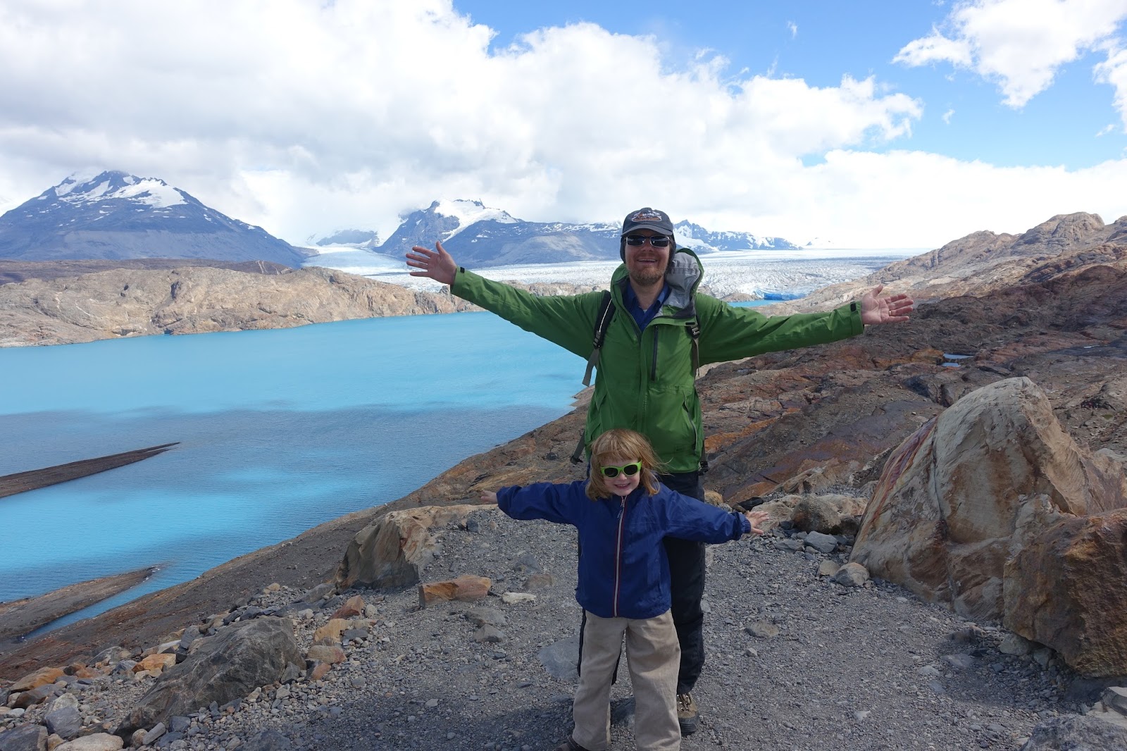
Our first day hike was  up a hill on the other side of Lago Grey from the central massif.  It was a short, steep and hot hike up to a Mirador, a lookout point.  We went through a little bit of brushy stuff and then started climbing.  It was quickly clear that Silas wasn't going to be able to make it up, so Mike, Maeve and the guide headed up and I headed down with Silas, barefoot, tied to my back with my scarf and his boots tied to my backpack on my belly.   We made it back down to the van, where the driver was, and Silas took a nap in the back seat while Mike and Maeve got to the views at the top, which is below.  I think it must have been less hot up top and it looks windy.


From the ridge line, you could see the Grey Glacier, which is connected to the Ice Sheet but is still retreating rapidly.  There is a huge glacial lake at the foot of the glacier that wasn't there a couple of decades ago, famous for its icebergs.  You can take a boat ride on the lake, but we'd decided we'd rather hike while in the park.  After Silas' nap, he and I changed him into crocks and headed out to a rocky beach at the foot of Lago Grey.  Mike and Maeve found us there playing when they got down.  That was a great area for the kids to play, but there was tons of cool wind coming off the glacier.

The next day, we went for a walk to another mirador (viewpoint) of the massif.  This was much more level and Maeve and Silas ran most of the way in their crocks.  This area was burned not too long ago, and there were no trees, except for the burned ones that were still standing, grey sentinels to the power of fire.   The burn was human-caused, and there is now tons of environmental education materials around and very strict fire regulations.  The environment is pretty hostile, and it takes a long time for the trees, principally Nothofagus species, to grow, so regrowth is slow.   The Nothofagus in the park were a different type from those we'd seen in Tierra del Fuego, they were much shorter but their wood is harder, more of a large shrub-tree, and were traditionally used for furniture and building.   They were also deciduous, like the varieties further south.

Family at the mirador Cuernos.  You can see the Glaciar de los Frances, a glaciar hanging off the top of the central Cerro Paine Grande.  There are actually a couple of glaciers there, the central one on top and a couple more that are formed from ice that falls from the central glacier.  This one isn't connected to the ice sheet, unlike its neighboring Grey Glacier, and is just formed on the mountain top.   You can also see the tree line on the other side of Lago Nordenskjold.   A decade ago, there were trees covering the area where we were hiking.  Now there's only scrub. Our hike this day included Salto Grande, a big waterfall from Lago Nordenskjold (in the background in this photo) going downstream until the water eventually runs into the Serrano River, running to the Puerto Natales fjord, and eventually to the Pacific Ocean.
Our camping experience was great.  We did a supported trip, meaning we had a guide, a driver, and a cook.  Our cook was super awesome and was psyched to have vegetarian clients.   It wasn't exactly back woods camping.  We rented gear from the company so we didn't have to bring our own stuff, saving a ton of space in the luggage.  They had 2 2-person tents for us, so the kids got their own tent.  The campgrounds in Chile are set up to not be very rustic.  There are shared bathrooms with running water during the day while the generator is on, and a dedicated cooking/hangout space for each campsite.  Then there is plenty of room for several tents.  Our campground was on the steppe, next to a river, and also had a cafe and playground.  There are many backwoods campgrounds in the park, as well as huts for hut to hut hiking though the massif. 

On our way out of the park, we took a quick detour to another waterfall, Cascada Paine, where Mike and Maeve scrambled down to river-level.  Silas was again napping in the van.  This part of the park hadn't burned, and you can see more scrubby growth.  You can also see the very grey quality of the water from all the glacial silt.

On our way out of the park, we stopped at an overlook on a lake, and on the hillside above, was a group of guanacos.  We'd seen some earlier in the day, including a baby, near the Salto Grande.  There were also flamencos, but too distant to get a good photo.  In the park, we saw tons of birds, jackrabbits, guanacos, nandus (Patagonian large bird, looks like a dark grey ostrich) and Andean condors.  We never saw any pumas.

Estancia Tercera is a tourist/working ranch outside the park.  We went there because we wanted to stay on an Estancia and because it was outside the park and would therefore let Silas ride a horse.  Inside the parks, both in Chile and Argentina, 5 year olds are too young for horse rides.  It was the kid's first time on horseback, and we rode over the steppe for an hour.  Both the kids were on leading reigns.  The first photo is of all of us getting ready to head out.

 Mike took this photo on our way back.  You can see the step, the Estancia buildings, the the Torres del Paine massif.  Riding the the steppe was amazing - we later walked some on the Argentina side of the range, but it's so dry, with scrubby grass and lots of prickly bushes.  The horse, sheep, and guanacos just push through it.  On horse back, we had a different perspective.  The Estancias are generally huge, with massive amounts of acreage.  This is because sheep are very destructive.  The grasses are pretty low in nutrients, and the sheep pull the whole grass clump up when they eat it.   Sheep and guanacos are not friendly and cannot co-habitate.  Cattle and guanacos can go-exist pretty well, cows impact the environment less (don't pull up the plants) but need more acreage just because they are big.  The Patagonian cows are not tasty, they are used for eating & milk, but the low value of the grasses there does not lead to the tasty Argentinean beef, which is mostly raised in the Pampas, the region nearer to Buenos Aires.  The guanacos, the native grazers, are much more picky. They use their flexible lips to pick off just the best, freshest shoots and don't eat whole plants, so they move a lot looking for tasty treats and don't cause erosion and environmental degradation.   On our ride over the Estancia, which does have some sheep but is mostly based on tourism (groups like ours, others who just use it as a hotel, and their gauchos and horses are also used to do long-distance trail riding in the park), we saw a couple groups of guanacos grazing.
We had amazing weather all throughout the south.  The skies were generally blue, it wasn't cold, and we didn't get hit with the famous Patagonian winds.  We ranged from wearing fleeces, jackets, gloves and hats, to being in short-sleeves some afternoons.  The sky was amazingly blue, with long vistas. 

To Torres del Paine

From Puerto Natales to Torres del Paine  January 18, 2015

We took an indirect route from Puerto Natales, Chile, to Torres del Paine National Park.  First, we did a catamaran cruise down the Fjord to National Park Bernardo O'Higgins.  This is a standard tourist day trip/excursion from Puerto Natales.   From there, we went up the Rio Serrano in zodiacs to get to Torres del Paine.  A great alternative to a two-way bus ride to the park.

The fjord was full of lovely waterfalls.  This is one of many we saw.  The fjord is called el Seno de Ultima Esperanza (the sound of Last Hope, maybe because it's a dead end and doesn't lead to the southern passage?) but was incredibly lovely.  It was the home of another canoe-living group of folks, the Kawasekar, which had a similar lifestyle to the canoerers in Tierra del Fuego, living naked just with sea lion fat, living in the boats with only temporary settlements on land, very strong upper bodies from rowing. 

View of the Andes from the fjord.

View of Torres del Paine massif from the fjord.  We learned to tell which were the horns and which were the towers and now I'm writing this up I can't remember!  But we got to see their irregular peaks from many angles over the next few days.

The Balmaceda glacier in the Bernardo O'Higgins National Park, at the end of the fjord.  It's not connected to the ice sheet, and is retreating.   Our visit to Patagonia was peppered with evidence of global warming and glacial melt.  At the base is a newly formed glacial lake, and on the walk there, we kept seeing poles that marked dates when the glacier had reached up to 500 M or more out from its current limit.  The newly formed lake of glacial melt is peppered with icebergs.  It's shrinking rapidly.  There were several Andean condors (ie buzzards, with a wingspan of over 2 meters) riding the thermals over the glacier, and one is in the upper L side of the photo, very small. 

After the walk to the glaciar, we borded a zodiac for the ride up the Serrano river to the campsite.  It was a nice day, but we suited up because of the wind.  Silas was very happy at the start of the ride, and soon fell asleep.  The rest of us checked out the scenery and a solitary sea lion that had braved coming up river to hunt for salmon.


This is looking back over the Serrano towards Bernardo O'Higgens park.  It was just lovely.  The river is pretty grey, full of glacial milk, and as we got closer to the park and the glaciers, you could see changes in color as a glacial or rain-fed tributary fed in.

After the ride, we had parilla (grill) before going on to our campsite.  The other guests had grilled meat with salad and bread, which we came to learn is the standard BBQ, sometimes with sausages, often with lamb.  We had omelets.  We often got disbelief or chagrin from folks when we said we were vegetarian, along the lines of, but in Argentina (and Chile) they grill so much meat, too bad you'll miss it and anyway what can you eat?  But the truth is, we rarely had problems.   Self catering helped, and I got very good at quickly perusing posted menus to see which restaurants would be better for us, but we had more issues overall with picky kids than finding vegetarian food.  Other new food words learned early in the trip:  palta (regional for avocado) and manjar (the Chilean version of dulce de leche).

Next up:  Torres del Paine.

Monday, June 15, 2015

Around Cape Horn

January 15-17, 2015 we took a 3-day cruise from Ushuaia, Argentina to Cape Horn and ending in Punta Arenas, Chile, travelling through the Beagle Chanel and Straight of Magellan.  It was incredible.  We like these small, educational cruises with lots of excursions.

We sailed out from Ushuaia and the next morning took off in zodiacs from our boat to land at Cape Horn, which is an island on the end of an archipelago south from Tierra del Fuego, which is itself a very large island separated from the American continent by the Straight of Magellan.  Silas loved the zodiac rides, which we took every day on excursions.  The next photo is of all of us on the Cape Horn island.  It was cool and very very windy.  Mike carried Silas a good bit, and kept getting pushed around by the wind.  There was a statue of an albatross on the highest hill of the island that had been built to withstand 200K winds, and had broken.  There is also a lighthouse, and the keeper and his family are part of the Chilean Navy.    All the islands in the background are part of Chile. 

The island itself was quite green, covered with grasses and plants but no trees.  It was a lovely high-summer day.

The next day, we got out to visit a glacier in Agostini national park, on an island south of the Beagle Chanel, that has a glacier.  This park and the Darwin Range, & islands are the tail end of the Andes, and the park is named for an Italian priest who was also a mountaineer and explored a lot of the southern Patagonian Ice Sheet.  The Marinelli glaciar,  the second one we'd seen after Glaciar Martial in Ushuaia, isn't connected to the ice sheet.  It's just hanging out all by it's lonesome, and like almost all the glaciers we saw, it's retreating rapidly. In this same park, we did a short hike to a lookout, found & tried some Pan de Indio, an edible fungus that only grows on Nothofagus trees, and saw a ton of beaver damage, which is prevalent around Tierra del Fuego.

On the way back to the zodiac launch point, we had a view of an awesome double rainbow and our cruise boat.  The kids were quite happy about the return trip, as the crew had hot chocolate waiting for us back at the boat.   We'd seen dolphins in the bay playing around with the zodiacs while we were waiting to board, but didn't see any more on the way back.

The last day on the boat, on the way in to Punta Arenas, the southernmost big town in Chile, we  stopped at Magdalena Island National Par.  The park has hundreds of thousands of pairs of Magellanic Penguins, as well as many gulls and skuas.  The babies here, like those in the Beagle Chanel, were starting to molt into their swimming feathers. We enjoyed the walk on the island, but were perhaps less overwhelmed because we'd already been up close and personal with penguins one time in Argentina.   At lunch we got dropped off in Punta Arenas, where we had 4 hours before needing to catch a 4 hour bus to Puerto Natales & camping in Torres del Paine.  

Punta Arenas was an interesting town, and deserved more time than we spent there. There was a huge cementary with large topiaries we spied on the way out of town, and several lovely mansions in town, one with a greenhouse with grapes,  that had been build by Patagonian cattle/sheep barrons. These families  (Braun-Menendez) were related to the families in Argentenian Patagonia and had & still have vast empires, including owning La Anonima, the largest Patagonian grocery chain that we used throughout our travels.  The also owned Estancias in Argentina where socialist workers were killed in the early 20th century for asking for better labor conditions.  The pervasiveness and historical power of these families were everywhere, and we ran into the same names over and over as being weathy owners, starting in Punta Arenas.  They are seen as pioneers, founding fathers, wealthy aristicrats, and evil capitalists who called in the army to kill their workers.  Their story is one of hard work leading to great wealth and the myth of immigration to make a better life.  It very much parallels similar myths of rags to riches pioneering possibilities of the westward expansion in the US.

Mike had been out of internet contact and would be for another week, so after a quick lunch in a pizza joint (not exciting) he hit an internet cafe while the kids and I picked up our luggage and went to the bus station, and off to the next leg of the trip.